• Home
  • Activities
    • Things To Do (overview)
    • Water Sports
      • Swimming Beaches
    • Trail Sports
    • Eat
  • Destinations
    • Places To Go (overview)
      • Maps
    • Lagoon
    • Parks
    • Food
    • Shopping
  • Events
    • Best Events
  • Maps
    • Maps (overview)
    • Parks Map
      • Lagoon Map
      • Swimming Beaches Map
    • Trails Map
    • Restaurants Map
    • Shopping Map
  • Pictures
    • Pictures – Events
    • Pictures – Parks
    • Pictures – Sports water
    • Pictures – Sports Trail
    • Pictures – Restaurants
  • Quick Links
    • Index
    • City Info
    • Blog
    • Admin

fostercityFUN

Levee Pedway – ONeal Slough

May 24, 2014 by Mike S

Run-Bike-Walk along O'Neal Slough

Run-Bike-Walk along O’Neal Slough

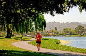
Foster City Levee Pedway (bikes allowed) follows the west side of O’Neal Slough from just north of Fashion Island Blvd (and Hwy 92) to the southern end of the slough.  This is a nice long flat trail that is excellent for biking. From there you can take to the Southern Canal Pedway (along the southern edge of Foster City) east to the San Francisco Bay Trail.  To the north of Levee Pedway is Harbortown Pedway.
Related Pages:

  • Harbortown Pedway – A prettier, but walking only (no bikes) trail just north of Levee Pedway
  • Best Foster City Trails and Map
  • Best Foster City Parks and Map
  • Top of page, Home page or website Index

Filed Under: Maps, Sports Tagged With: trails

Find more about Weather in Foster City, CA Click for weather forecast
half price tickets

Top  |  Home  |  Site & Advertising Policies  |  Log in
© 2018 · Thought-Management.com, Foster City, CA 94404